Plant site compatibility
- Home
- /
- Technical Manual
- /
- Landscape criteria
- /
- Plant compatibility
- /
- Plant site compatibility
Background
Plants require more irrigation and maintenance if planted in unsuitable conditions. If established plants have been sited appropriately, they will survive with minimal irrigation during dry periods. Florida Water Star identifies the following primary site characteristics influencing plant health and survival:
- Hardiness zone
- Soil pH
- Soil moisture
- Sunlight
- Salt tolerance
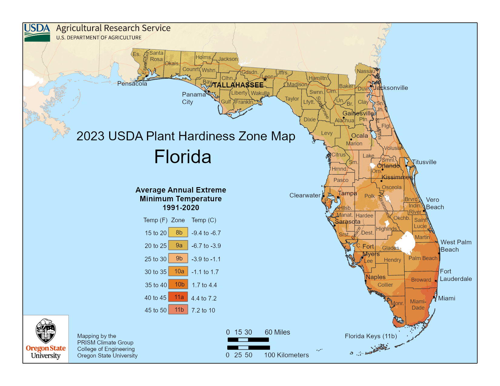
Hardiness zone is a geographic region in which a plant is capable of growing, as defined by climatic conditions, including its ability to withstand the minimum temperatures of the zone. The U.S. Department of Agriculture determines hardiness zones.
All landscape plants should be adapted to survive within the property’s climate (hardiness) zone. Microclimates, caused by proximity to a large water body, for example, can exist on a site and can create modified site conditions for growth. Such microclimates should be detailed by the Inspector.
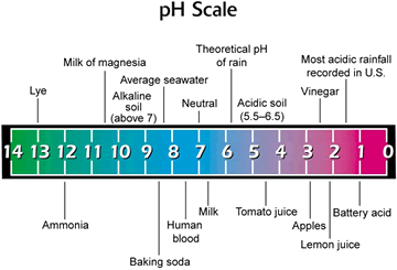
Soil pH is the measure of the soil’s acidity or alkalinity. The pH can range in value from 1 to 14; the value of 7 represents neutrality. Locating a plant in a soil with a different pH than recommended for that species can affect absorption of nutrients and create stressful conditions that can contribute to pest problems.
Acidic soil has a pH level below 7, while alkaline soil has a pH level above 7. Florida Water Star does not require that Inspectors measure a site’s pH.
Soil moisture is the water held in the spaces between soil particles. Dry soil: See xeric. Moist soil: See mesic. Wet soil: See hydric. Many sites have uniform soil moisture. However, some sites have a wide soil moisture range that will significantly affect landscape health.
Sunlight:
- Full sun indicates locations receive more than 6 to 8 hours of sunlight a day (e.g., southeast areas, treeless lots, new subdivisions with new landscapes, large open expanses of turf).
- Partial sun areas receive 5 to 6 hours of sunlight in either the morning with afternoon shade or in the afternoon with morning shade.
- Areas with full shade receive less than 5 hours of sunlight a day (e.g., northwest areas, deep shade under canopy trees, areas between homes on zero-lot lines, bedding areas under roof eaves).
Hardiness zones
Hardiness zones vary across the United States. This map shows hardiness zones for each county in Florida (zones 8a-11a). A hardiness zone is a geographic area in which a plant is capable of growing based on factors such as its ability to withstand certain temperatures. For best results in your landscape, choose plants best suited for the zone in which you live.
The hardiness zones map was developed by the U.S. Department of Agriculture.
Salt tolerance
A plant that tolerates a large amount of salt in the soil or in the wind (salt spray) has salt tolerance. Some plants may be tolerant of salt spray, but not salt water, especially in coastal communities using reclaimed water. For Florida Water Star purposes, salinity should only be an issue for coastal locations and, in some cases, where municipal reuse water is the primary source for irrigation.
The following table is an example submittal for a Florida Water Star Commercial/Institutional project, detailing site characteristics that are relevant to overall plant site compatibility.
| Florida Water Star Commerical/Institutional Site Information and Narrative | ||||
|---|---|---|---|---|
| Site Environmental Characteristics | ||||
| Hardiness Zone | pH | Soil Moisture | Sun | Salinity |
| 9a | Neutral | Moist | Full–partial shade | Low |
| Soil Characteristics | ||||
| This site has sandy soils that were compacted during the construction process. Soils and elevation/moisture levels are consistent across the site. | ||||
| Additional General Description | ||||
| The building is currently the primary source of shading to landscaped areas, because no trees have been preserved on-site. | ||||
Requirements and certification
A minimum of 90% of plant selections are compatible with site-specific conditions such as sunlight, soil type and salinity.
| Silver | Gold | Commercial/Institutional |
|---|---|---|
| Required | Required | Required |
This practice interprets the suitability of a plant for the overall site conditions. Credit is awarded based upon the percentage of plants in the landscape beds that meet the site-specific growing conditions. Plant beds should be designed such that at maturity they cover 60% of the bed.
Typically, the program Inspector should use information in the design drawings and the waterwise plant database to assess the compatibility of each landscape bed. Confirmation of planted species and site conditions must occur on-site.
- Credit is allocated by calculating the percentage of compatible species as a percentage of the entire number of species. For example, if 90 of 100 species are compatible with site conditions, then 90% is credited.
- Alternatively, the Inspector may award credit based on the total number of plants.
For existing landscapes, Inspectors must use their own judgment and potentially approve compliance with this practice, if existing plants are surviving well in the absence of regular irrigation.
Program tip
In some cases, microclimates create conditions that do not conform to the information contained in the waterwise plant database, or in other plant references. Microclimates can expand the range of a plant to survive during extreme temperature fluctuations, usually winter freezes. In this situation, the Inspector should request a variance and provide plant references that document the plant species’ ability to thrive in the microclimate.


